Examples can be found and tried by the "<ahref="/solutions/dataecosystem/apis/p4d-data-ecosystem-crs-catalog-service-v2/search-crs"target="_blank">Try it out (opens in another window)</a>".
Generate an example token (Custom Token button), 'Try it out' and
inspect the Request. You will find the the populated http request.
### API Versions <a name="api_versions"><a>
The current API is version 2. The previous version, version 1, is still
operational. It is, however, recommended to transition to the latest version 2.
To ease the this transition, see the section [Transitioning V2 to V2](#v1_to_v2_transition).
The main difference between the versions are:
- Simpler encoding of the so-called essence of the elements, i.e.
coordinate reference systems (CRSs), cartographic transformations (CTs)
and areas of use.
- Shorter JSON property names leading to more concise persistable reference (see example below)
strings.
- Turn some GET to POST requests where the length of the URL path grew too long.
Data are now passed in the request body and are no longer subject to encoding.
**Note**: persistable reference strings from version 1 are accepted by the
catalog implementation of version2 - but not vice versa. Related services
consume any version of persistable reference string, for example
The four values span a bounding box in spherical coordinates:
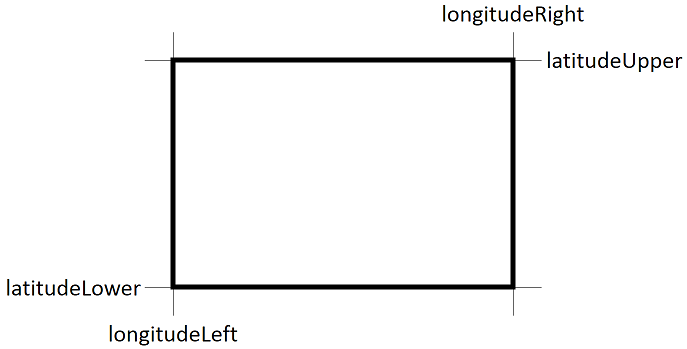
Let us run an example with the following constraints:
- Only return CRS, which are bound to a cartographic transformation to WGS 84 or based on WGS 84. This becomes a query constraint.
- Only return CRS, which are based on NAD27, EPSG, 4267. This becomes a query constraint.
- Longitude range between 100°W and 80°W \[-100, -80\].
- Latitude range between 20°N and 50°N \[20, 50\].
- Limit the response to the first two items in the catalog.
- Request returned data to contain the JSON structure of the essence rather than the persistable reference (default).
Parameter|Value in path
---------|-------------------------------
{longitudeLeft}|```-100``` (in degrees; negative W, positive E, range \[-180,180\]
{latitudeLower}|```20``` (in degrees; negative S, positive N, range \[-90,90\]
{longitudeRight}|```-80``` (in degrees; negative W, positive E, range \[-180,180\]
{latitudeUpper}|```50``` (in degrees; negative S, positive N, range \[-90,90\]
{offset}|```0``` (default 0)
{limit}|```2``` (default 100)
{mode}|What kind of response `persistable_reference` (default), populates `namedReference`) or `essence`, populates `essence` property or `persistable_and_essence` to have both `namedReference` and `essence` populated.
Query constraint passed via the request body (JSON encoded). For valid search keywords, please see the [keyword table below](#crs-search-keywords-v2):
<ahref="/solutions/dataecosystem/apis/p4d-data-ecosystem-crs-catalog-service-v2/search-crs"target="_blank">Try this example by opening the API catalog in another window</a>.
The request with the parameters above creates the following response:
<aname="search-response-example"></a>
<details><summary>Response example</summary>
```
{
"offset": 0,
"count": 2,
"totalCount": 49,
"crses": [
{
"description": "NAD_1927_StatePlane_Louisiana_North_FIPS_1701 bound to NAD_1927_To_WGS_1984_79_CONUS [26781,15851]",
When populating a multi-purpose CRS selector, this method offers access to all CRSs of any sub-type as defined in the catalog:
```
GET /api/v2/crs?offset={offset}&limit={limit}
```
Parameter|Value
---------|-----------------
{offset}|```0``` (default 0)
{limit}|```1000``` (default 100, -1 for all)
{mode}|What kind of response `persistable_reference` (default), populates `namedReference`) or `essence`, populates `essence` property or `persistable_and_essence` to have both `namedReference` and `essence` populated.
Open <ahref="/solutions/dataecosystem/apis/p4d-data-ecosystem-crs-catalog-service-v2/get-all-crs"target="_blank">Try it out: get-all-crs</a>
The response structure is of type [CRSResults](#CRSResults), which is the same structure as for the [search use case above](#search-response-example).
<details><summary>CURL Get all CRS command</summary>
In some cases apps may want to cache the entire catalog of coordinate reference systems and cartographic transforms.
The CRS catalog service supports this with the following two methods:
1.```/catalog``` to request the catalog summary -
Open <ahref="/solutions/dataecosystem/apis/p4d-data-ecosystem-crs-catalog-service-v2/get-catalog-summary"target="_blank">Try it out in new window</a>. The response is of type [Catalog](#catalog-v2).
The response comes with a number of arrays, but all of them are empty. Corresponding to each array there is a count. API clients can decide which arrays to populate and e.g. keep in a long-term cache.
1.```/catalog/attributes``` to request the last modification date of the catalog.
Open <ahref="/solutions/dataecosystem/apis/p4d-data-ecosystem-crs-catalog-service/crsgetcatalogattributes"target="_blank">Try it out in new window</a>. The response if of type [CatalogAttributes](#catalogattributes-v1).
The latter method allows apps to determine when the cached contents has become stale and needs a refresh.
The following table associates the arrays with the appropriate API methods to populate.
Array/List | Type | Count| API | Description
-----------|------|------|-----|------------
**lateBoundCRSes** | [**list\[LateBoundCRS\]**](#LateBoundCRS) | **lateBoundCRSesCount** | <ahref="/solutions/dataecosystem/apis/p4d-data-ecosystem-crs-catalog-service-v2/get-all-lateboundcrs"target="_blank">Try it out: get-all-lateboundcrs</a> | The list of late-bound coordinate reference systems.
**earlyBoundCRSes** | [**list\[EarlyBoundCRS\]**](#EarlyBoundCRS) | **earlyBoundCRSesCount** | <ahref="/solutions/dataecosystem/apis/p4d-data-ecosystem-crs-catalog-service-v2/get-all-earlyboundcrs"target="_blank">Try it out: get-all-earlyboundcrs</a> | The list of early-bound coordinate reference systems.
**compoundCRSes** | [**list\[CompoundCRS\]**](#CompoundCRS) | **compoundCRSesCount** | <ahref="/solutions/dataecosystem/apis/p4d-data-ecosystem-crs-catalog-service-v2/get-all-compoundcrs"target="_blank">Try it out: get-all-compoundcrs</a> | The list of compound coordinate reference systems.
**singleCTs** | [**list\[SingleCT\]**](#SingleCT) | **singleCTsCount** | <ahref="/solutions/dataecosystem/apis/p4d-data-ecosystem-crs-catalog-service-v2/get-all-singlect"target="_blank">Try it out: get-all-singlect</a> | The list of single cartographic transforms.
**compoundCTs** | [**list\[CompoundCT\]**](#CompoundCT) | **compoundCTsCount** | <ahref="/solutions/dataecosystem/apis/p4d-data-ecosystem-crs-catalog-service-v2/get-all-compoundct"target="_blank">Try it out: get-all-compoundct</a> | The list of compound cartographic transforms.
**areaOfUses** | [**list\[AreaOfUse\]**](#AreaOfUse-v2) | **areaOfUseCount** | <ahref="/solutions/dataecosystem/apis/p4d-data-ecosystem-crs-catalog-service-v2/get-all-areas-use"target="_blank">Try it out: get-all-areas-use</a> | The list of areas of use.
[Back to table of contents](#TOC)
## CRS Catalog API Overview <a name="preferred-api-v2"></a>
Method|Try it out (in new window)|Request Type|Response Type
`GET /api/v2/catalog`|<ahref="/solutions/dataecosystem/apis/p4d-data-ecosystem-crs-catalog-service-v2/get-catalog-summary"target="_blank">Try it out: get-catalog-summary</a>|-|[Catalog](#catalog-v2)
`GET /api/v2/catalog/attributes`|<ahref="/solutions/dataecosystem/apis/p4d-data-ecosystem-crs-catalog-service-v2/get-catalog-attributes"target="_blank">Try it out: get-catalog-attributes</a>|-|[CatalogAttributes](#CatalogAttributes-v2)
|***Coordinate Reference System API***| |
`GET /api/v2/crs`|<ahref="/solutions/dataecosystem/apis/p4d-data-ecosystem-crs-catalog-service-v2/get-all-crs"target="_blank">Try it out: get-all-crs</a>|-|[CRSResults](#CRSResults)
`POST /api/v2/crs`|<ahref="/solutions/dataecosystem/apis/p4d-data-ecosystem-crs-catalog-service-v2/get-one-crs"target="_blank">Try it out: get-one-crs</a>|[CRSRequest](#CRSRequest)|[CRS](#CRS)
`GET /api/v2/lateboundcrs`|<ahref="/solutions/dataecosystem/apis/p4d-data-ecosystem-crs-catalog-service-v2/get-all-lateboundcrs"target="_blank">Try it out: get-all-lateboundcrs</a>|-|[LateBoundCRSResults](#LateBoundCRSResults)
`POST /api/v2/lateboundcrs`|<ahref="/solutions/dataecosystem/apis/p4d-data-ecosystem-crs-catalog-service-v2/get-one-lateboundcrs"target="_blank">Try it out: get-one-lateboundcrs</a>|[LateBoundCRSRequest](#LateBoundCRSRequest)|[LateBoundCRS](#LateBoundCRS)
`GET /api/v2/earlyboundcrs`|<ahref="/solutions/dataecosystem/apis/p4d-data-ecosystem-crs-catalog-service-v2/get-all-earlyboundcrs"target="_blank">Try it out: get-all-earlyboundcrs</a>|-|[EarlyBoundCRSResults](#EarlyBoundCRSResults)
`POST /api/v2/earlyboundcrs`|<ahref="/solutions/dataecosystem/apis/p4d-data-ecosystem-crs-catalog-service-v2/get-all-earlyboundcrs"target="_blank">Try it out: get-all-earlyboundcrs</a>|[EarlyBoundCRSRequest](#EarlyBoundCRSRequest)|[EarlyBoundCRS](#EarlyBoundCRS)
`GET /api/v2/compoundcrs`|<ahref="/solutions/dataecosystem/apis/p4d-data-ecosystem-crs-catalog-service-v2/get-all-compoundcrs"target="_blank">Try it out: get-all-compoundcrs</a>|-|[CompoundCRSResults](#CompoundCRSResults)
`POST /api/v2/compoundcrs`|<ahref="/solutions/dataecosystem/apis/p4d-data-ecosystem-crs-catalog-service-v2/get-one-compoundcrs"target="_blank">Try it out: get-one-compoundcrs</a>|[CompoundCRSRequest](#CompoundCRSRequest)|[CompoundCRS](#CompoundCRS)
`POST /api/v2/search/crs`|<ahref="/solutions/dataecosystem/apis/p4d-data-ecosystem-crs-catalog-service-v2/search-crs"target="_blank">Try it out: search-crs</a>|[SearchCRSRequest](#SearchCRSRequest), [search keywords](#crs-search-keywords-v2) |[CRSResults](#CRSResults)
|***Cartographic Transformations API***| |
`GET /api/v2/ct`|<ahref="/solutions/dataecosystem/apis/p4d-data-ecosystem-crs-catalog-service-v2/get-all-ct"target="_blank">Try it out: get-all-ct</a>|-|[CTResults](#CTResults)
`POST /api/v2/ct`|<ahref="/solutions/dataecosystem/apis/p4d-data-ecosystem-crs-catalog-service-v2/get-one-ct"target="_blank">Try it out: get-one-ct</a>|[CTRequest](#CTRequest)|[CT](#CT)
`GET /api/v2/singlect`|<ahref="/solutions/dataecosystem/apis/p4d-data-ecosystem-crs-catalog-service-v2/get-all-singlect"target="_blank">Try it out: get-all-singlect</a>|-|[SingleCTResults](#SingleCTResults)
`POST /api/v2/singlect`|<ahref="/solutions/dataecosystem/apis/p4d-data-ecosystem-crs-catalog-service-v2/get-one-singlect"target="_blank">Try it out: get-one-singlect</a>|[SingleCTRequest](#SingleCTRequest)|[SingleCT](#SingleCT)
`GET /api/v2/compoundct`|<ahref="/solutions/dataecosystem/apis/p4d-data-ecosystem-crs-catalog-service-v2/get-all-compoundct"target="_blank">Try it out: get-all-compoundct</a>|-|[CompoundCTResults](#CompoundCTResults)
`POST /api/v2/compoundct`|<ahref="/solutions/dataecosystem/apis/p4d-data-ecosystem-crs-catalog-service-v2/get-one-compoundct"target="_blank">Try it out: get-one-compoundct</a>|[CompoundCTRequest](#CompoundCTRequest)|[CompoundCT](#CompoundCT)
`POST /api/v2/search/ct`|<ahref="/solutions/dataecosystem/apis/p4d-data-ecosystem-crs-catalog-service-v2/search-ct"target="_blank">Try it out: search-ct</a>|[SearchCTRequest](#SearchCTRequest), [search keywords](#ct-search-keywords-v2)|[CTResults](#CTResults)
|***Area of Use API***| |
`GET /api/v2/area`|<ahref="/solutions/dataecosystem/apis/p4d-data-ecosystem-crs-catalog-service-v2/get-all-areas-use"target="_blank">Try it out: get-all-areas-use</a>|-|[AreaOfUseResults](#AreaOfUseResults)
`POST /api/v2/area`|<ahref="/solutions/dataecosystem/apis/p4d-data-ecosystem-crs-catalog-service-v2/get-one-area-use"target="_blank">Try it out: get-one-area-use</a>|[AreaOfUseRequest](#AreaOfUseRequest)|[AreaOfUse](#AreaOfUse)
`POST /api/v2/search/area`|<ahref="/solutions/dataecosystem/apis/p4d-data-ecosystem-crs-catalog-service-v2/search-area-use"target="_blank">Try it out: search-area-use</a>|[SearchAreaOfUseRequest](#SearchAreaOfUseRequest), [search keywords](#area-search-keywords)|[AreaOfUseResults](#AreaOfUseResults)
`transformationReady:`|CRS's transformation readiness, i.e. is the CRS ready to be used in datum transformations (true or false)|`transformationReady:true` or `transformationReady:false`
**areaOfUseCount** | **int** | The total number of Area Of Uses in the catalog. | \[optional\]
**areaOfUses** | [**list\[AreaOfUse\]**](#AreaOfUse-v2) | The complete list of areas of use. | \[optional\]
**attributes** | [**CatalogAttributes**](#CatalogAttributes-v2) | The name and last modification time of the catalog. | \[optional\]
**compoundCTsCount** | **int** | The total number of compoundCTs in the catalog. | \[optional\]
**compoundCTs** | [**list\[CompoundCT\]**](#CompoundCT) | The complete list of compound cartographic transforms | \[optional\]
**compoundCRSesCount** | **int** | The total number of compoundCRSes in the catalog. | \[optional\]
**compoundCRSes** | [**list\[CompoundCRS\]**](#CompoundCRS) | The complete list of compound coordinate reference systems. | \[optional\]
**earlyBoundCRSesCount** | **int** | The total number of earlyBoundCRSes in the catalog. | \[optional\]
**earlyBoundCRSes** | [**list\[EarlyBoundCRS\]**](#EarlyBoundCRS) | The complete list of early-bound coordinate reference systems. | \[optional\]
**lateBoundCRSesCount** | **int** | The total number of lateBoundCRSes in the catalog. | \[optional\]
**lateBoundCRSes** | [**list\[LateBoundCRS\]**](#LateBoundCRS) | The complete list of late-bound coordinate reference systems. | \[optional\]
**singleCTsCount** | **int** | The total number of singleCTs in the catalog. | \[optional\]
**singleCTs** | [**list\[SingleCT\]**](#SingleCT) | The complete list of single cartographic transforms | \[optional\]
<details><summary>Catalog example</summary>
```
{
"lateBoundCRSes": [],
"lateBoundCRSesCount": 1151,
"earlyBoundCRSes": [],
"earlyBoundCRSesCount": 1059,
"compoundCRSesCount": 60,
"singleCTs": [],
"singleCTsCount": 227,
"compoundCTs": [],
"compoundCTsCount": 1,
"areaOfUseCount": 953,
"attributes": {
"name": "Minimal EPSG standard catalog",
"description": "Catalog containing selected ESRI's standard EPSG coordinate reference systems and cartographic transforms, and limited early-bound coordinate reference systems where the CRS and TRF area-of-use intersect; augmented by Ocean factory catalog standard definitions",
"lastModified": "2018-06-11T15:39:55.1229803Z"
},
"areasOfUse": [],
"compoundCRSes": []
}
```
</details>
[Back to API Data Structures](#response-data-structures-v2) - [Back to table of contents](#TOC)
**crstype** | **str** | The type of the LateBoundCRS. | \[optional\]
**source** | **str** | The source of the LateBoundCRS. | \[optional\]
**transformationReady** | **bool** | The Transformation readiness of the LateBoundCRS. | \[optional\]
**baseCRSAuthorityCode** | [**AuthCode**](#AuthCode) | The base authority code of the LateBoundCRS. | \[optional\]
**aliasNames** | **list\[str\]** | Alias names for this LateBoundCRS. | \[optional\]
**axisUnits** | **list\[str\]** | Axis Unit Essences. | \[optional\]
**numberOfAxes** | **int** | The NumberOfAxes of the LateBoundCRS. | \[optional\]
**description** | **str** | The description of the LateBoundCRS. | \[optional\]
**lastModified** | **str** | The LastModified of the LateBoundCRS. | \[optional\]
**areaOfUse** | [**AreaOfUse**](#AreaOfUse-v2) | The Area of Use for this CRS. | \[optional\]
**deprecationInfo** | [**CRSDeprecationInfo**](#CRSDeprecationInfo) | Only if deprecated - additional information and potentially a recommended replacement CRS. | \[optional\]
**namedReference** | [**NamedReference**](#NamedReference) | A structure containing the item Name and the persistable Reference string; populated if the request mode='persistableReference'. | \[optional\]
**essence** | [**LateBoundCRSEssence**](#LateBoundCRSEssence) | The Essence of the LateBoundCRS; populated if the request mode='essence'. | \[optional\]
**crsType** | **str** | The type of the EarlyBoundCRS. | \[optional\]
**source** | **str** | The source of the EarlyBoundCRS. | \[optional\]
**transformationReady** | **bool** | The TransformationReadyness of the EarlyBoundCRS. | \[optional\]
**baseCRSAuthorityCode** | [**AuthCode**](#AuthCode) | The base authority code of the LateBoundCRS. | \[optional\]
**aliasNames** | **list\[str\]** | Alias names for this EarlyBoundCRS. | \[optional\]
**axisUnits** | **list\[str\]** | Axis Unit Essences. | \[optional\]
**numberOfAxes** | **int** | The NumberOfAxes of the EarlyBoundCRS. | \[optional\]
**description** | **str** | The description of the EarlyBoundCRS. | \[optional\]
**lastModified** | **str** | The LastModified of the EarlyBoundCRS. | \[optional\]
**areaOfUse** | [**AreaOfUse**](#AreaOfUse-v2) | The Area of Use for this CRS. | \[optional\]
**deprecationInfo** | [**CRSDeprecationInfo**](#CRSDeprecationInfo) | Only if deprecated - additional information and potentially a recommended replacement CRS. | \[optional\]
**namedReference** | [**NamedReference**](#NamedReference) | A structure containing the item Name and the persistable Reference string; populated if the request mode='persistableReference'. | \[optional\]
**essence** | [**EarlyBoundCRSEssence**](#EarlyBoundCRSEssence) | The Essence of the EarlyBoundCRS. | \[optional\]
<details><summary>EarlyBoundCRS example</summary>
```
{
"description": "ED_1950_UTM_Zone_31N bound to ED_1950_To_WGS_1984_24 [23031,1613]",
**type** | **str** | The type identifier, fixed to 'EBC'. | \[default to 'EBC'\]
**name** | **str** | The name of the early-bound coordinate reference system. |
**ver** | **str** | The engine version issuing the definition. | \[optional\]
**lateBoundCRS** | [**LateBoundCRSEssence**](#LateBoundCRSEssence) | Late-bound CRS, which is bound to a single (st) or compound (ct) transformation to WGS 84. |
**single_ct** | [**SingleCTEssence**](#SingleCTEssence) | Single Transformation, which binds the late-bound CRS (lb) to WGS 84. If absent, a compound transformation (ct) must be present. | \[optional\]
**compound_ct** | [**CompoundCTEssence**](#CompoundCTEssence) | Compound transformation, which binds the late-bound CRS (lb) to WGS 84. If absent, a single transformation (st) must be present. | \[optional\]
**auth_code** | [**AuthCode**](#AuthCode) | The authority code for this item. | \[optional\]
[Back to API Data Structures](#response-data-structures-v2) - [Back to table of contents](#TOC)
**crstype** | **str** | The type of the CompoundCRS. | \[optional\]
**source** | **str** | The source of the CompoundCRS. | \[optional\]
**transformationReady** | **bool** | The TransformationReadyness of the CompoundCRS. | \[optional\]
**baseCRSAuthorityCode** | [**AuthCode**](#AuthCode) | The base authority code of the LateBoundCRS. | \[optional\]
**aliasNames** | **list\[str\]** | Alias names for this CompoundCRS. | \[optional\]
**axisUnits** | **list\[str\]** | Axis Unit Essences. | \[optional\]
**numberOfAxes** | **int** | The NumberOfAxes of the CompoundCRS. | \[optional\]
**description** | **str** | The description of the CompoundCRS. | \[optional\]
**lastModified** | **str** | The LastModified of the CompoundCRS. | \[optional\]
**areaOfUse** | [**AreaOfUse**](#AreaOfUse-v2) | The Area of Use for this CRS. | \[optional\]
**deprecationInfo** | [**CRSDeprecationInfo**](#CRSDeprecationInfo) | Only if deprecated - additional information and potentially a recommended replacement CRS. | \[optional\]
**namedReference** | [**NamedReference**](#NamedReference) | A structure containing the item Name and the persistable Reference string; populated if the request mode='persistableReference'. | \[optional\]
**essence** | [**CompoundCRSEssence**](#CompoundCRSEssence) | The Essence of the CompoundCRS. | \[optional\]
<details><summary>CompoundCRS example</summary>
```
{
"description": "Horizontal CRS: CRS Scope: Large and medium scale topographic mapping and engineering survey.; Vertical CRS: CRS Scope: Geodesy. | Remarks: Zero-height surface resulting from the application of the EGM96 geoid model to the WGS 84 ellipsoid. Replaces EGM84 height (CRS code 5798). Replaced by EGM2008 height (CRS code 3855). | Information Source: NASA http://cddis.gsfc.nasa.gov/926/egm96/egm96.html",
"lastModified": "20180611",
"aliasNames": [],
"namedReference": {
"name": "WGS 84 / UTM zone 31N + EGM96 height",
"persistableReference": "{\"horzLateBoundCRS\":{\"wkt\":\"PROJCS[\\\"WGS_1984_UTM_Zone_31N\\\",GEOGCS[\\\"GCS_WGS_1984\\\",DATUM[\\\"D_WGS_1984\\\",SPHEROID[\\\"WGS_1984\\\",6378137.0,298.257223563]],PRIMEM[\\\"Greenwich\\\",0.0],UNIT[\\\"Degree\\\",0.0174532925199433]],PROJECTION[\\\"Transverse_Mercator\\\"],PARAMETER[\\\"False_Easting\\\",500000.0],PARAMETER[\\\"False_Northing\\\",0.0],PARAMETER[\\\"Central_Meridian\\\",3.0],PARAMETER[\\\"Scale_Factor\\\",0.9996],PARAMETER[\\\"Latitude_Of_Origin\\\",0.0],UNIT[\\\"Meter\\\",1.0],AUTHORITY[\\\"EPSG\\\",32631]]\",\"ver\":\"PE_10_3_1\",\"name\":\"WGS_1984_UTM_Zone_31N\",\"authCode\":{\"auth\":\"EPSG\",\"code\":\"32631\"},\"type\":\"LBC\"},\"vertLateBoundCRS\":{\"wkt\":\"VERTCS[\\\"EGM96_Geoid\\\",VDATUM[\\\"EGM96_Geoid\\\"],PARAMETER[\\\"Vertical_Shift\\\",0.0],PARAMETER[\\\"Direction\\\",1.0],UNIT[\\\"Meter\\\",1.0],AUTHORITY[\\\"EPSG\\\",5773]]\",\"ver\":\"PE_10_3_1\",\"name\":\"EGM96_Geoid\",\"authCode\":{\"auth\":\"EPSG\",\"code\":\"5773\"},\"type\":\"LBC\"},\"ver\":\"PE_10_3_1\",\"name\":\"WGS 84 / UTM zone 31N + EGM96 height\",\"authCode\":{\"auth\":\"SLB\",\"code\":\"326315773\"},\"type\":\"CC\"}"
"description": "Between 0°E and 6°E, northern hemisphere between equator and 84°N, onshore and offshore. Algeria. Andorra. Belgium. Benin. Burkina Faso. Denmark - North Sea. France. Germany - North Sea. Ghana. Luxembourg. Mali. Netherlands. Niger. Nigeria. Norway. Spain. Togo. United Kingdom (UK) - North Sea.",
"lastModified": "20150104",
"aliasNames": [],
"namedReference": null,
"name": "World - N hemisphere - 0°E to 6°E - by country",
"deprecationInfo": null,
"essence": {
"name": null,
"authCode": {
"auth": "EPSG",
"code": "2060"
},
"type": "AOU",
"boundBox": {
"lonMin": 0,
"latMin": 0,
"lonMax": 6,
"latMax": 84
}
}
}
}
```
</details>
[Back to API Data Structures](#response-data-structures-v2) - [Back to table of contents](#TOC)
**type** | **str** | The type identifier. fixed to 'CC'. | \[default to 'CC'\]
**name** | **str** | The name of the compound coordinate reference system. |
**ver** | **str** | The engine version issuing the definition. | \[optional\]
**horzLateBoundCRS** | [**LateBoundCRSEssence**](#LateBoundCRSEssence.) | The horizontal CRS of a Compound CRS as late-bound CRS. If 'horzLateBoundCRS' is non-null, 'horzEarlyBoundCRS' must be null. | \[optional\]
**horzEarlyBoundCRS** | [**EarlyBoundCRSEssence**](#EarlyBoundCRSEssence) | The horizontal CRS of a Compound CRS as early-bound CRS. If 'horzEarlyBoundCRS' is non-null, 'horzLateBoundCRS' must be null. | \[optional\]
**vertLateBoundCRS** | [**LateBoundCRSEssence**](#LateBoundCRSEssence) | The vertical CRS of the Compound CRS as late-bound CRS. If 'vertLateBoundCRS' is non-null, 'vertEarlyBoundCRS' must be null. | \[optional\]
**vertEarlyBoundCRS** | [**EarlyBoundCRSEssence**](#EarlyBoundCRSEssence) | The vertical CRS of the Compound CRS as early-bound CRS. If 'vertEarlyBoundCRS' is non-null, 'vertLateBoundCRS' must be null. | \[optional\]
**authCode** | [**AuthCode**](#AuthCode) | The authority code for this item. | \[optional\]
[Back to API Data Structures](#response-data-structures-v2) - [Back to table of contents](#TOC)
**source** | **str** | The source of the SingleCT. | \[optional\]
**aliasNames** | **list\[str\]** | Alias names for this SingleCT. | \[optional\]
**description** | **str** | The description of the SingleCT. | \[optional\]
**fromCRSAuthorityCode** | [**AuthCode**](#AuthCode) | The 'from CRS' authority code of this SingleCT. | \[optional\]
**toCRSAuthorityCode** | [**AuthCode**](#AuthCode) | The 'to CRS' authority code of this SingleCT. | \[optional\]
**lastModified** | **str** | The LastModified of the SingleCT. | \[optional\]
**areaOfUse** | [**AreaOfUse**](#AreaOfUse-v2) | The Area of Use for this SingleCT. | \[optional\]
**deprecationInfo** | [**CTDeprecationInfo**](#CTDeprecationInfo) | Only if deprecated - additional information and potentially a recommended replacement CT. | \[optional\]
**namedReference** | [**NamedReference**](#NamedReference) | A structure containing the item Name and the persistable Reference string; populated if the request mode='persistableReference'. | \[optional\]
**essence** | [**SingleCTEssence**](#SingleCTEssence) | The Essence of the SingleCT. | \[optional\]
<details><summary>SingleCT example</summary>
```
{
"description": "Coord Op Scope: Recommended for oil industry use in US Gulf of Mexico (GoM). Accuracy at 67% confidence level is 0.15m onshore, 5m nearshore and undetermined farther offshore. | Tfm Accuracy: 5 | Remarks: Transformation taken from NAD27 to NAD83 (1) (code 1241) assuming that NAD83 is equivalent to WGS 84 within the accuracy of this tfm. Uses NADCON method which expects longitudes positive west; EPSG CRS codes 4267 and 4326 have longitudes positive east. | Information Source: OGP",
**source** | **str** | The source of the CompoundCT. | \[optional\]
**aliasNames** | **list\[str\]** | Alias names for this CompoundCT. | \[optional\]
**description** | **str** | The description of the CompoundCT. | \[optional\]
**fromCRSAuthorityCode** | [**AuthCode**](#AuthCode) | The 'from CRS' authority code of this CompoundCT. | \[optional\]
**toCRSAuthorityCode** | [**AuthCode**](#AuthCode) | The 'to CRS' authority code of this CompoundCT. | \[optional\]
**lastModified** | **str** | The LastModified of the CompoundCT. | \[optional\]
**areaOfUse** | [**AreaOfUse**](#AreaOfUse-v2) | The Area of Use for this CompoundCT. | \[optional\]
**deprecationInfo** | [**CTDeprecationInfo**](#CTDeprecationInfo) | Only if deprecated - additional information and potentially a recommended replacement CT. | \[optional\]
**namedReference** | [**NamedReference**](#NamedReference) | A structure containing the item Name and the persistable Reference string; populated if the request mode='persistableReference'. | \[optional\]
**essence** | [**CompoundCTEssence**](#CompoundCTEssence) | The Essence of the CompoundCT. | \[optional\]
<details><summary>CompoundCT example</summary>
```
{
"description": "Fallback Coord Op Scope: Recommended for oil industry use in US Gulf of Mexico (GoM). Accuracy at 67% confidence level is 0.15m onshore, 5m nearshore and undetermined farther offshore. | Tfm Accuracy: 5 | Remarks: Transformation taken from NAD27 to NAD83 (1) (code 1241) assuming that NAD83 is equivalent to WGS 84 within the accuracy of this tfm. Uses NADCON method which expects longitudes positive west; EPSG CRS codes 4267 and 4326 have longitudes positive east. | Information Source: OGP/Coord Op Scope: Approximation at the +/- 1m level. | Tfm Accuracy: 1 | Remarks: Parameter file is from NAD27 to NAD83 (4) (code 1313) assuming that NAD83 is equivalent to WGS 84 within the accuracy of the transformation. | Information Source: OGP",
"lastModified": "20180611",
"aliasNames": [],
"namedReference": {
"name": "Fallback NAD27 to WGS 84 (79)/NAD27 to WGS 84 (33)",
"persistableReference": "{\"policy\":\"Fallback\",\"cts\":[{\"wkt\":\"GEOGTRAN[\\\"NAD_1927_To_WGS_1984_79_CONUS\\\",GEOGCS[\\\"GCS_North_American_1927\\\",DATUM[\\\"D_North_American_1927\\\",SPHEROID[\\\"Clarke_1866\\\",6378206.4,294.9786982]],PRIMEM[\\\"Greenwich\\\",0.0],UNIT[\\\"Degree\\\",0.0174532925199433]],GEOGCS[\\\"GCS_WGS_1984\\\",DATUM[\\\"D_WGS_1984\\\",SPHEROID[\\\"WGS_1984\\\",6378137.0,298.257223563]],PRIMEM[\\\"Greenwich\\\",0.0],UNIT[\\\"Degree\\\",0.0174532925199433]],METHOD[\\\"NADCON\\\"],PARAMETER[\\\"Dataset_conus\\\",0.0],AUTHORITY[\\\"EPSG\\\",15851]]\",\"ver\":\"PE_10_3_1\",\"name\":\"NAD_1927_To_WGS_1984_79_CONUS\",\"authCode\":{\"auth\":\"EPSG\",\"code\":\"15851\"},\"type\":\"ST\"},{\"wkt\":\"GEOGTRAN[\\\"NAD_1927_To_WGS_1984_33\\\",GEOGCS[\\\"GCS_North_American_1927\\\",DATUM[\\\"D_North_American_1927\\\",SPHEROID[\\\"Clarke_1866\\\",6378206.4,294.9786982]],PRIMEM[\\\"Greenwich\\\",0.0],UNIT[\\\"Degree\\\",0.0174532925199433]],GEOGCS[\\\"GCS_WGS_1984\\\",DATUM[\\\"D_WGS_1984\\\",SPHEROID[\\\"WGS_1984\\\",6378137.0,298.257223563]],PRIMEM[\\\"Greenwich\\\",0.0],UNIT[\\\"Degree\\\",0.0174532925199433]],METHOD[\\\"NTv2\\\"],PARAMETER[\\\"Dataset_canada/Ntv2_0\\\",0.0],AUTHORITY[\\\"EPSG\\\",1693]]\",\"ver\":\"PE_10_3_1\",\"name\":\"NAD_1927_To_WGS_1984_33\",\"authCode\":{\"auth\":\"EPSG\",\"code\":\"1693\"},\"type\":\"ST\"}],\"ver\":\"PE_10_3_1\",\"name\":\"Fallback NAD27 to WGS 84 (79)/NAD27 to WGS 84 (33)\",\"authCode\":{\"auth\":\"SLB\",\"code\":\"158511693\"},\"type\":\"CT\"}"
},
"source": "Ocean catalog",
"essence": {
"authCode": {
"auth": "SLB",
"code": "158511693"
},
"type": "CT",
"ver": "PE_10_3_1",
"name": "Fallback NAD27 to WGS 84 (79)/NAD27 to WGS 84 (33)",
**essence** | [**AnyCRSEssence**](#AnyCRSEssence) | The CRS's essence either a LateBoundCRSEssence, EarlyBoundCRSEssence or CompoundCRSEssence. | \[optional\]
**crsType** | **str** | The type of ths CRS. | \[optional\]
**source** | **str** | The source of ths CRS. | \[optional\]
**transformation_ready** | **bool** | The Transformation readiness of this CRS. | \[optional\]
**baseCRSAuthorityCode** | [**AuthCode**](#AuthCode) | The base authority code of this CRS. | \[optional\]
**aliasNames** | **list\[str\]** | Alias names for this CRS. | \[optional\]
**axisUnits** | **list\[str\]** | Axis Unit Essences. | \[optional\]
**numberOfAxes** | **int** | The NumberOfAxes of this CRS. | \[optional\]
**description** | **str** | The description of this CRS. | \[optional\]
**lastModified** | **str** | The LastModified of this CRS. | \[optional\]
**areaOfUse** | [**AreaOfUse**](#AreaOfUse-v2) | The Area of Use for this CRS. | \[optional\]
**deprecation_info** | [**CRSDeprecationInfo**](#CRSDeprecationInfo) | Only if deprecated - additional information and potentially a recommended replacement CRS. | \[optional\]
**namedReference** | [**NamedReference**](#NamedReference) | A structure containing the item Name and the persistable Reference string; populated if the request mode='persistable_reference'. | \[optional\]
**name** | **str** | The name of the coordinate reference system. |
**ver** | **str** | The engine version issuing the definition. | \[optional\]
**wkt** | **str** | Well-known text (Esri style) of the late-bound coordinate reference system. | \[optional\]
**lateBoundCRS** | [**LateBoundCRSEssence**](#LateBoundCRSEssence) | Late-bound CRS, which is bound to a single (st) or compound (ct) transformation to WGS 84. | \[optional\]
**singleCT** | [**SingleCTEssence**](#SingleCTEssence) | Single Transformation, which binds the late-bound CRS (lb) to WGS 84. If absent, a compound transformation (ct) must be present. | \[optional\]
**compoundCT** | [**CompoundCTEssence**](#CompoundCTEssence) | Compound transformation, which binds the late-bound CRS (lb) to WGS 84. If absent, a single transformation (st) must be present. | \[optional\]
**horzLateBoundCRS** | [**LateBoundCRSEssence**](#LateBoundCRSEssence) | The horizontal CRS of a Compound CRS as late-bound CRS. If 'horzLateBoundCRS' is non-null, 'horzEarlyBoundCRS' must be null. | \[optional\]
**horzEarlyBoundCRS** | [**EarlyBoundCRSEssence**](#EarlyBoundCRSEssence) | The horizontal CRS of a Compound CRS as early-bound CRS. If 'horzEarlyBoundCRS' is non-null, 'horzLateBoundCRS' must be null. | \[optional\]
**vertLateBoundCRS** | [**LateBoundCRSEssence**](#LateBoundCRSEssence) | The vertical CRS of the Compound CRS as late-bound CRS. If 'vertLateBoundCRS' is non-null, 'vertEarlyBoundCRS' must be null. | \[optional\]
**vertEarlyBoundCRS** | [**EarlyBoundCRSEssence**](#EarlyBoundCRSEssence) | The vertical CRS of the Compound CRS as early-bound CRS. If 'vertEarlyBoundCRS' is non-null, 'vertLateBoundCRS' must be null. | \[optional\]
**authCode** | [**AuthCode**](#AuthCode) | The authority code for this item. | \[optional\]
[Back to API Data Structures](#response-data-structures-v2) - [Back to table of contents](#TOC)
**source** | **str** | The source of the cartographic transformation. | \[optional\]
**aliasNames** | **list[str]** | Alias names for this cartographic transformation. | \[optional\]
**description** | **str** | The description of the cartographic transformation. | \[optional\]
**fromCRSAuthorityCode** | [**AuthCode**](#AuthCode) | The 'from CRS' authority code of this cartographic transformation. | \[optional\]
**toCRSAuthorityCode** | [**AuthCode**](#AuthCode) | The 'to CRS' authority code of this cartographic transformation. | \[optional\]
**lastModified** | **str** | The LastModified of the cartographic transformation. | \[optional\]
**areaOfUse** | [**AreaOfUse**](#AreaOfUse-v2) | The Area of Use for this cartographic transformation. | \[optional\]
**deprecationInfo** | [**CTDeprecationInfo**](#CTDeprecationInfo) | Only if deprecated - additional information and potentially a recommended replacement cartographic transformation. | \[optional\]
**namedReference** | [**NamedReference**](#NamedReference) | A structure containing the item Name and the persistable Reference string; populated if the request mode='persistable_reference'. | \[optional\]
**essence** | [**AnyCTEssence**](#AnyCTEssence) | The Essence of the cartographic transformation. | \[optional\]
**id** | **str** | The Internal Id of the AreaOfUse. | \[optional\]
**name** | **str** | The name of the AreaOfUse. | \[optional\]
**description** | **str** | The description of the AreaOfUse. | \[optional\]
**lastModified** | **str** | The LastModified of the AreaOfUse. | \[optional\]
**namedReference** | [**NamedReference**](#NamedReference) | A structure containing the item Name and the persistable Reference string; populated if the request mode='persistableReference'. | \[optional\]
**essence** | [**AreaOfUseEssence**](#AreaOfUseEssence-v2) | The Essence of the AreaOfUse. | \[optional\]
<details><summary>AreaOfUse example</summary>
```
{
"description": "United States (USA) - CONUS including EEZ -onshore and offshore - Alabama; Arizona; Arkansas; California; Colorado; Connecticut; Delaware; Florida; Georgia; Idaho; Illinois; Indiana; Iowa; Kansas; Kentucky; Louisiana; Maine; Maryland; Massachusetts; Michigan; Minnesota; Mississippi; Missouri; Montana; Nebraska; Nevada; New Hampshire; New Jersey; New Mexico; New York; North Carolina; North Dakota; Ohio; Oklahoma; Oregon; Pennsylvania; Rhode Island; South Carolina; South Dakota; Tennessee; Texas; Utah; Vermont; Virginia; Washington; West Virginia; Wisconsin; Wyoming. US Gulf of Mexico (GoM) OCS.",
**persistableReference** | **str** | The persistable reference string, either the essence of the LateBoundCRS serialized into a JSON string or an encoded string (version 1). | \[optional\]
**essence** | [**LateBoundCRSEssence**](#LateBoundCRSEssence) | The essence for the LateBoundCRS. Either the essence or persistableReference must be non-null. | \[optional\]
[Back to API Data Structures](#response-data-structures-v2) - [Back to table of contents](#TOC)
**persistableReference** | **str** | The persistable reference string, either the essence of the EarlyBoundCRS serialized into a JSON string or an encoded string (version 1). | \[optional\]
**essence** | [**EarlyBoundCRSEssence**](#EarlyBoundCRSEssence) | The essence for the EarlyBoundCRS. Either the essence or persistableReference must be non-null. | \[optional\]
[Back to API Data Structures](#response-data-structures-v2) - [Back to table of contents](#TOC)
**persistableReference** | **str** | The persistable reference string, either the essence of the CompoundCRS serialized into a JSON string or an encoded string (version 1). | \[optional\]
**essence** | [**CompoundCRSEssence**](#CompoundCRSEssence) | The essence for the CompoundCRS. Either the essence or persistableReference must be non-null. | \[optional\]
[Back to API Data Structures](#response-data-structures-v2) - [Back to table of contents](#TOC)
**persistableReference** | **str** | The persistable reference string, either the essence of the CRS serialized into a JSON string or an encoded string (version 1). | \[optional\]
**essence** | [**AnyCRSEssence**](#AnyCRSEssence) | The essence Json for the CRS. Either the essence or persistableReference must be non-null. | \[optional\]
[Back to API Data Structures](#response-data-structures-v2) - [Back to table of contents](#TOC)
**persistableReference** | **str** | The persistable reference string, either the essence of the SingleCT serialized into a JSON string or an encoded string (version 1). | \[optional\]
**essence** | [**SingleCTEssence**](#SingleCTEssence) | The essence for the SingleCT. Either the essence or persistableReference must be non-null. | \[optional\]
[Back to API Data Structures](#response-data-structures-v2) - [Back to table of contents](#TOC)
**persistableReference** | **str** | The persistable reference string, either the essence of the CompoundCT serialized into a JSON string or an encoded string (version 1). | \[optional\]
**essence** | [**CompoundCTEssence**](#CompoundCTEssence) | The essence for the CompoundCT. Either the essence or persistableReference must be non-null. | \[optional\]
[Back to API Data Structures](#response-data-structures-v2) - [Back to table of contents](#TOC)
**persistableReference** | **str** | The persistable reference string, either the essence of the cartographic transform (CT) serialized into a JSON string or an encoded string (version 1). | \[optional\]
**essence** | [**AnyCTEssence**](#AnyCTEssence) | The essence Json for the CT. Either the essence or persistableReference must be non-null. | \[optional\]
[Back to API Data Structures](#response-data-structures-v2) - [Back to table of contents](#TOC)
**persistableReference** | **str** | The persistable reference string, either the essence of the AreaOfUse serialized into a JSON string or an encoded string (version 1). | \[optional\]
**essence** | [**AreaOfUseEssence**](#AreaOfUseEssence-v2) | Area of use essence. Either the essence or persistableReference must be non-null. | \[optional\]
[Back to API Data Structures](#response-data-structures-v2) - [Back to table of contents](#TOC)
**cts** | [**list\[CT\]**](#CT) | An array of (any sub-type of) cartographic transforms | \[optional\]
**count** | **int** | Number of elements in the response. | \[optional\]
**offset** | **int** | Offset to the first catalog item in the response, as set in the request. | \[optional\]
**totalCount** | **int** | Number of elements in the catalog. | \[optional\]
[Back to API Data Structures](#response-data-structures-v2) - [Back to table of contents](#TOC)
## Legacy API (Version 1) <a name="legacy-api-v1"></a>
Further sections:
*[API Transition V1 to V2](#transition-v1-to-v2)
*[API Data Structures (V1)](#response-data-structures-v1)
*[Catalog Item Types V1](#catalog-item-types-v1)
*[Response Types V1](#response-types-v1)
Method|Try it out (in new window)|Response Type
------|--------------------------|-------------
|***Coordinate Reference System API V1***|
`GET /api/v1/coordinateReferenceSystem`|<ahref="/solutions/dataecosystem/apis/p4d-data-ecosystem-crs-catalog-service/crsgetallcoordinatereferencesystems"target="_blank">Try it out: crsgetallcoordinatereferencesystems</a>|[CoordinateReferenceSystemResults](#coordinatereferencesystemresults)
`GET /api/v1/coordinateReferenceSystem/reference/{pr}`|<ahref="/solutions/dataecosystem/apis/p4d-data-ecosystem-crs-catalog-service/crsgetcoordinatereferencesystem"target="_blank">Try it out: crsgetcoordinatereferencesystem</a>|[CoordinateReferenceSystem](#coordinateseferencesystem)
`GET /api/v1/lateBoundCoordinateReferenceSystem`|<ahref="/solutions/dataecosystem/apis/p4d-data-ecosystem-crs-catalog-service/crsgetlateboundcoordinatereferencesystems"target="_blank">Try it out: crsgetlateboundcoordinatereferencesystems</a>|[LateBoundCoordinateReferenceSystemResults](#lateboundcoordinatereferencesystemresults)
`GET /api/v1/lateBoundCoordinateReferenceSystem/reference/{pr}`|<ahref="/solutions/dataecosystem/apis/p4d-data-ecosystem-crs-catalog-service/crsgetlateboundcoordinatereferencesystem"target="_blank">Try it out: crsgetlateboundcoordinatereferencesystem</a>|[LateBoundCoordinateReferenceSystem](#lateboundcoordinatereferencesystem)
`GET /api/v1/earlyBoundCoordinateReferenceSystem`|<ahref="/solutions/dataecosystem/apis/p4d-data-ecosystem-crs-catalog-service/crsgetearlyboundcoordinatereferencesystems"target="_blank">Try it out: crsgetearlyboundcoordinatereferencesystems</a>|[EarlyBoundCoordinateReferenceSystemResults](#earlyboundcoordinatereferencesystemresults)
`GET /api/v1/earlyBoundCoordinateReferenceSystem/reference/{pr}`|<ahref="/solutions/dataecosystem/apis/p4d-data-ecosystem-crs-catalog-service/crsgetearlyboundcoordinatereferencesystem"target="_blank">Try it out: crsgetearlyboundcoordinatereferencesystem</a>|[EarlyBoundCoordinateReferenceSystem](#earlyboundcoordinatereferencesystem)
`GET /api/v1/compoundCoordinateReferenceSystem`|<ahref="/solutions/dataecosystem/apis/p4d-data-ecosystem-crs-catalog-service/crsgetcompoundcoordinatereferencesystems"target="_blank">Try it out: crsgetcompoundcoordinatereferencesystems</a>|[CompoundCoordinateReferenceSystemResults](#compoundcoordinatereferencesystemresults)
`GET /api/v1/compoundCoordinateReferenceSystem/reference/{pr}`|<ahref="/solutions/dataecosystem/apis/p4d-data-ecosystem-crs-catalog-service/crsgetcompoundcoordinatereferencesystem"target="_blank">Try it out: crsgetcompoundcoordinatereferencesystem</a>|[CompoundCoordinateReferenceSystem](#compoundcoordinatereferencesystem)
`GET /api/v1/coordinateReferenceSystem/search`|<ahref="/solutions/dataecosystem/apis/p4d-data-ecosystem-crs-catalog-service/crssearchcoordinatereferencesystems"target="_blank">Try it out: crssearchcoordinatereferencesystems</a>, [search keywords](#crs-search-keywords-v1)|[CoordinateReferenceSystemResults](#coordinatereferencesystemresults)
|***Cartographic Transformations API V1***|
`GET /api/v1/cartographicTransform`|<ahref="/solutions/dataecosystem/apis/p4d-data-ecosystem-crs-catalog-service/crsgetallcartographictransforms"target="_blank">Try it out: crsgetallcartographictransforms</a>|[CartographicTransformResults](#cartographictransformresults)
`GET /api/v1/cartographicTransform/reference/{pr}`|<ahref="/solutions/dataecosystem/apis/p4d-data-ecosystem-crs-catalog-service/crsgetcartographictransform"target="_blank">Try it out: crsgetcartographictransform</a>|[CartographicTransform](#cartographictransform)
`GET /api/v1/singleCartographicTransform`|<ahref="/solutions/dataecosystem/apis/p4d-data-ecosystem-crs-catalog-service/crsgetsinglecartographictransforms"target="_blank">Try it out: crsgetsinglecartographictransforms</a>|[SingleCartographicTransformResults](#singlecartographictransformresults)
`GET /api/v1/singleCartographicTransform/reference/{pr}`|<ahref="/solutions/dataecosystem/apis/p4d-data-ecosystem-crs-catalog-service/crsgetsinglecartographictransform"target="_blank">Try it out: crsgetsinglecartographictransform</a>|[SingleCartographicTransform](#singlecartographictransform)
`GET /api/v1/compoundCartographicTransform`|<ahref="/solutions/dataecosystem/apis/p4d-data-ecosystem-crs-catalog-service/crsgetcompoundcartographictransforms"target="_blank">Try it out: crsgetcompoundcartographictransforms</a>|[CompoundCartographicTransformResults](#compoundcartographictransformresults)
`GET /api/v1/compoundCartographicTransform/reference/{pr}`|<ahref="/solutions/dataecosystem/apis/p4d-data-ecosystem-crs-catalog-service/crsgetcompoundcartographictransform"target="_blank">Try it out: crsgetcompoundcartographictransform</a>|[CompoundCartographicTransform](#compoundcartographictransform)
`GET /api/v1/cartographicTransform/search`|<ahref="/solutions/dataecosystem/apis/p4d-data-ecosystem-crs-catalog-service/crssearchcartographictransforms"target="_blank">Try it out: crssearchcartographictransforms</a>, [search keywords](#ct-search-keywords-v1)|[CartographicTransformResults](#cartographictransformresults)
|***Area of Use API V1***|
`GET /api/v1/areaOfUse`|<ahref="/solutions/dataecosystem/apis/p4d-data-ecosystem-crs-catalog-service/crsgetareasofuse"target="_blank">Try it out: crsgetareasofuse</a>|[AreaOfUseResults](#areaofuseresults)
`GET /api/v1/areaOfUse/reference/{pr}`|<ahref="/solutions/dataecosystem/apis/p4d-data-ecosystem-crs-catalog-service/crsgetareaofuse"target="_blank">Try it out: crsgetareaofuse</a>|[AreaOfUse](#areaofuse)
`GET /api/v1/areaOfUse/search`|<ahref="/solutions/dataecosystem/apis/p4d-data-ecosystem-crs-catalog-service/crssearchareasofuse"target="_blank">Try it out: crssearchareasofuse</a>, [search keywords](#area-search-keywords)|[AreaOfUseResults](#areaofuseresults)
[Back to Legacy API V1](#legacy-api-v1)[Back to table of contents](#TOC)
#### CRS search keywords, deprecated version V1 <a name="crs-search-keywords-v1"></a>
The following table lists the keyword codes for the Lucene style query elements.
Keyword code|Constrain by|Values in use or example
------------|------------|-------------
`name:`|specific words/sub-strings in the name| Example: `name:*ED50*`
`description:`|specific sub-strings in the description|
`type:`| Type code for the CRS | `type:LBCRS` (late-bound or un-bound CRS), `type:EBCRS` (early-bound CRS), `type:CCRS` (compound CRS)
`transformationReady:`|CRS's transformation readiness, i.e. is the CRS ready to be used in datum transformations (true or false)|`transformationReady:true` or `transformationReady:false`
[Back to Legacy API V1](#legacy-api-v1)[Back to table of contents](#TOC)
#### CT search keywords, deprecated version V1 <a name="ct-search-keywords-v1"></a>
The following table lists the keyword codes for the Lucene style query elements.
Keyword code|Constrain by|Values in use or example
------------|------------|-------------
`name:`|specific words/sub-strings in the name| Example: `name:*NAD_1927*`
`description:`|specific sub-strings in the description|
`type:`|Type code for the Cartographic Transform (CT) | `type:ST` (single CT), `type:CT` (compound CT)
`policy:`|compound transformation policy|`policy:fallback` or `policy:concatenated`
[Back to Legacy API V1](#legacy-api-v1)[Back to table of contents](#TOC)
## Transition from deprecated Version 1 to current version (V2) APIs <a name="transition-v1-to-v2"></a>
The following table provides the aid to transition. The links open the 'Try it out' in a new window.
V1 Method|V1 'Try it out' Link|V2 Method|V2 'Try it out' Link|Notes
---------|-------|--------|-------|-----
`GET /api/v1/catalog`|<ahref="/solutions/dataecosystem/apis/p4d-data-ecosystem-crs-catalog-service/crsgetcatalog"target="_blank">crsgetcatalog</a>|`GET /api/v2/catalog`|<ahref="/solutions/dataecosystem/apis/p4d-data-ecosystem-crs-catalog-service-v2/get-catalog-summary"target="_blank">get-catalog-summary</a>|The V2 catalog response does not populate the arrays of catalog items. Use the V2 GET requests to populate the catalog item arrays. The V1 allCoordinateReferenceSystems ai achieved by combining V2 lateBoundCRSes, earlyBoundCRSes and compoundCRSes. The V1 allCartographicTransforms is achieved by combining the V2 singleCTs and compoundCTs.
`GET /api/v1/coordinateReferenceSystem/{pr}`|<ahref="/solutions/dataecosystem/apis/p4d-data-ecosystem-crs-catalog-service/crsgetcoordinatereferencesystem"target="_blank">crsgetcoordinatereferencesystem</a>|`POST /api/v2/crs`|<ahref="/solutions/dataecosystem/apis/p4d-data-ecosystem-crs-catalog-service-v2/get-one-crs"target="_blank">get-one-crs</a>|The persistableReference string {pr} moves into the request body.
`GET /api/v1/lateBoundCoordinateReferenceSystem/{pr}`|<ahref="/solutions/dataecosystem/apis/p4d-data-ecosystem-crs-catalog-service/crsgetlateboundcoordinatereferencesystem"target="_blank">crsgetlateboundcoordinatereferencesystem</a>|`POST /api/v2/lateboundcrs`|<ahref="/solutions/dataecosystem/apis/p4d-data-ecosystem-crs-catalog-service-v2/get-one-lateboundcrs"target="_blank">get-one-lateboundcrs</a>|The persistableReference string {pr} moves into the request body.
`GET /api/v1/earlyBoundCoordinateReferenceSystem/{pr}`|<ahref="/solutions/dataecosystem/apis/p4d-data-ecosystem-crs-catalog-service/crsgetearlyboundcoordinatereferencesystem"target="_blank">crsgetearlyboundcoordinatereferencesystem</a>|`POST /api/v2/earlyboundcrs`|<ahref="/solutions/dataecosystem/apis/p4d-data-ecosystem-crs-catalog-service-v2/get-one-earlyboundcrs"target="_blank">get-one-earlyboundcrs</a>|The persistableReference string {pr} moves into the request body.
`GET /api/v1/compoundCoordinateReferenceSystem/{pr}`|<ahref="/solutions/dataecosystem/apis/p4d-data-ecosystem-crs-catalog-service/crsgetcompoundcoordinatereferencesystem"target="_blank">crsgetcompoundcoordinatereferencesystem</a>|`POST /api/v2/compoundcrs`|<ahref="/solutions/dataecosystem/apis/p4d-data-ecosystem-crs-catalog-service-v2/get-one-compoundcrs"target="_blank">get-one-compoundcrs</a>|The persistableReference string {pr} moves into the request body.
`GET /api/v1/coordinateReferenceSystem/search`|<ahref="/solutions/dataecosystem/apis/p4d-data-ecosystem-crs-catalog-service/crssearchcoordinatereferencesystems"target="_blank">crssearchcoordinatereferencesystems</a>|`POST /api/v2/search/crs`|<ahref="/solutions/dataecosystem/apis/p4d-data-ecosystem-crs-catalog-service-v2/search-crs"target="_blank">search-crs</a>|The keyword query moves to the request body; the optional query constraints stay in in int url path.
`GET /api/v1/cartographicTransform/reference/{pr}`|<ahref="/solutions/dataecosystem/apis/p4d-data-ecosystem-crs-catalog-service/crsgetcartographictransform"target="_blank">crsgetcartographictransform</a>|`POST /api/v2/ct`|<ahref="/solutions/dataecosystem/apis/p4d-data-ecosystem-crs-catalog-service-v2/get-one-ct"target="_blank">get-one-ct</a>|The persistableReference string {pr} moves into the request body.
`GET /api/v1/singleCartographicTransform/reference/{pr}`|<ahref="/solutions/dataecosystem/apis/p4d-data-ecosystem-crs-catalog-service/crsgetsinglecartographictransform"target="_blank">crsgetsinglecartographictransform</a>|`POST /api/v2/singlect`|<ahref="/solutions/dataecosystem/apis/p4d-data-ecosystem-crs-catalog-service-v2/get-one-singlect"target="_blank">get-one-singlect</a>|The persistableReference string {pr} moves into the request body.
`GET /api/v1/compoundCartographicTransform/reference/{pr}`|<ahref="/solutions/dataecosystem/apis/p4d-data-ecosystem-crs-catalog-service/crsgetcompoundcartographictransform"target="_blank">crsgetcompoundcartographictransform</a>|`POST /api/v2/compoundct`|<ahref="/solutions/dataecosystem/apis/p4d-data-ecosystem-crs-catalog-service-v2/get-one-compoundct"target="_blank">get-one-compoundct</a>|The persistableReference string {pr} moves into the request body.
`GET /api/v1/cartographicTransform/search`|<ahref="/solutions/dataecosystem/apis/p4d-data-ecosystem-crs-catalog-service/crssearchcartographictransforms"target="_blank">crssearchcartographictransforms</a>|`POST /api/v2/search/ct`|<ahref="/solutions/dataecosystem/apis/p4d-data-ecosystem-crs-catalog-service-v2/search-ct"target="_blank">search-ct</a>|The keyword query moves to the request body; the optional query constraints stay in in int url path.
`GET /api/v1/areaOfUse/reference/{pr}`|<ahref="/solutions/dataecosystem/apis/p4d-data-ecosystem-crs-catalog-service/crsgetareaofuse"target="_blank">crsgetareaofuse</a>|`POST /api/v2/area`|<ahref="/solutions/dataecosystem/apis/p4d-data-ecosystem-crs-catalog-service-v2/get-one-area-use"target="_blank">get-one-area-use</a>|The persistableReference string {pr} moves into the request body.
`GET /api/v1/areaOfUse/search`|<ahref="/solutions/dataecosystem/apis/p4d-data-ecosystem-crs-catalog-service/crssearchareasofuse"target="_blank">crssearchareasofuse</a>|`POST /api/v2/search/area`|<ahref="/solutions/dataecosystem/apis/p4d-data-ecosystem-crs-catalog-service-v2/search-area-use"target="_blank">search-area-use</a>|The keyword query moves to the request body; the optional query constraints stay in in int url path.
[Back to Legacy API V1](#legacy-api-v1)[Back to table of contents](#TOC)
## API Data Structures (Version 1) <a name="response-data-structures-v1" ></a>
**allCartographicTransforms** | [**list\[CartographicTransform\]**](#cartographictransform) | The complete list of cartographic transforms. | \[optional\]
**allCoordinateReferenceSystems** | [**list\[CoordinateReferenceSystem\]**](#coordinatereferencesystem) | The complete list of coordinate reference systems. | \[optional\]
**areasOfUse** | [**list\[AreaOfUse\]**](#areaofuse) | The complete list of areas of use. | \[optional\]
**attributes** | [**CatalogAttributes**](#catalogattributes-v1) | The name and last modification time of the catalog. | \[optional\]
**compoundCartographicTransforms** | [**list\[CompoundCartographicTransform\]**](#compoundcartographictransform) | The complete list of compound cartographic transforms | \[optional\]
**compoundCoordinateReferenceSystems** | [**list\[CompoundCoordinateReferenceSystem\]**](#compoundcoordinatereferencesystem) | The complete list of compound coordinate reference systems. | \[optional\]
**earlyBoundCoordinateReferenceSystems** | [**list\[EarlyBoundCoordinateReferenceSystem\]**](#earlyboundcoordinatereferencesystem) | The complete list of early-bound coordinate reference systems. | \[optional\]
**lateBoundCoordinateReferenceSystems** | [**list\[LateBoundCoordinateReferenceSystem\]**](#lateboundcoordinatereferencesystem) | The complete list of late-bound coordinate reference systems. | \[optional\]
**singleCartographicTransforms** | [**list\[SingleCartographicTransform\]**](#singlecartographictransform) | The complete list of single cartographic transforms | \[optional\]
[Back to Legacy API V1](#legacy-api-v1)[Back to API Data Structures (Version 1)](#response-data-structures-v1) - [Back to table of contents](#TOC)
**aliasNames** | **list\[str\]** | Array of alternative names - used by search. | \[optional\]
**areaOfUse** | [**AreaOfUse**](#areaofuse) | The intended area of use for this cartographic transform. | \[optional\]
**deprecationInfo** | [**TrfDeprecationInfo**](#trfdeprecationinfo) | Only if deprecated - additional information and potentially a recommended replacement transform. | \[optional\]
**description** | **str** | A text further describing this cartographic transform. | \[optional\]
**essence** | [**CartographicTransformEssence**](#cartographictransformessence) | The essence of this CartographicTransform | \[optional\]
**fromCrsAuthorityCode** | [**AuthorityCode**](#authorityCode) | The AuthorityCode of the 'from' coordinate reference system. | \[optional\]
**lastModified** | **str** | The last modification date of this item (YYYYMMDD). | \[optional\]
**source** | **str** | Description of the source of this item. | \[optional\]
**toCrsAuthorityCode** | [**AuthorityCode**](#authorityCode) | The AuthorityCode of the 'to' coordinate reference system. | \[optional\]
[Back to Legacy API V1](#legacy-api-v1)[Back to API Data Structures (Version 1)](#response-data-structures-v1) - [Back to table of contents](#TOC)
**authorityCode** | [**AuthorityCode**](#authoritycode) | The AuthorityCode of this cartographic transform. | \[optional\]
**engineVersion** | **str** | Spatial engine type and version, which issued the spatial definitions. | \[optional\]
**name** | **str** | Name of this cartographic transform | \[optional\]
**persistableReference** | **str** | The persistable reference string containing the full parameterization of the cartographic transform. | \[optional\]
**type** | **str** | The item type code (STRF for single TRFs or CTRF for compound TRFs) |
**wellKnownText** | **str** | The well-known text representation for the cartographic transform. Only populated for single cartographic transforms (type=STRF). | \[optional\]
**policy** | **str** | The policy describing how the list of transforms is to be processed. Only populated for compound TRFs (type=CTRF). | \[optional\]
**trfAuthorityCodes** | [**list\[AuthorityCode\]**](#authoritycode) | The ordered list of AuthorityCode representing the compound CartographicTransformations. Only populated for compound TRFs (type=CTRF). | \[optional\]
**trfReferences** | **list\[str\]** | The ordered list of persistable references. Only populated for compound TRFs (type=CTRF). | \[optional\]
**trfs** | [**list\[CartographicTransform\]**](#cartographictransform) | The ordered list of CartographicTransform. Only populated for compound TRFs (type=CTRF). | \[optional\]
[Back to Legacy API V1](#legacy-api-v1)[Back to API Data Structures (Version 1)](#response-data-structures-v1) - [Back to table of contents](#TOC)
**aliasNames** | **list\[str\]** | Array of alternative names - used by search. | \[optional\]
**areaOfUse** | [**AreaOfUse**](#areaofuse) | The intended area of use for this compound transform. | \[optional\]
**essence** | [**CompoundCartographicTransformEssence**](#compoundcartographictransformessence) | The essence of this CompoundCartographicTransform | \[optional\]
**deprecationInfo** | [**TrfDeprecationInfo**](#trfdeprecationinfo) | Only if deprecated - additional information and potentially a recommended replacement transform. | \[optional\]
**description** | **str** | A text further describing this compound transform. | \[optional\]
**fromCrsAuthorityCode** | [**AuthorityCode**](#authoritycode) | The AuthorityCode of the 'from' coordinate reference system. | \[optional\]
**lastModified** | **str** | The last modification date of this item (YYYYMMDD). | \[optional\]
**source** | **str** | Description of the source of this item. | \[optional\]
**toCrsAuthorityCode** | [**AuthorityCode**](#authoritycode) | The AuthorityCode of the 'to' coordinate reference system. | \[optional\]
[Back to Legacy API V1](#legacy-api-v1)[Back to API Data Structures (Version 1)](#response-data-structures-v1) - [Back to table of contents](#TOC)
**authorityCode** | [**AuthorityCode**](#authoritycode) | The AuthorityCode of the compound cartographic transform. | \[optional\]
**engineVersion** | **str** | Spatial engine type and version, which issued the spatial definitions. | \[optional\]
**name** | **str** | Name of the compound cartographic transform. | \[optional\]
**persistableReference** | **str** | The persistable references string containing the full description. | \[optional\]
**policy** | **str** | The policy describing how the list of transforms is to be processed - 'Fallback': trying the ordered list of transforms until a point is successfully transformed; 'Concatenated': apply the transformations in a chain connecting input/output. | \[optional\]
**trfAuthorityCodes** | [**list\[AuthorityCode\]**](#authoritycode) | The ordered list of AuthorityCode representing the CartographicTransformations. | \[optional\]
**trfReferences** | **list\[str\]** | The ordered list of persistable references. | \[optional\]
**trfs** | [**list\[CartographicTransform\]**](#cartographictransform) | The ordered list of CartographicTransform. | \[optional\]
**type** | **str** | The item type code | \[optional\]
[Back to Legacy API V1](#legacy-api-v1)[Back to API Data Structures (Version 1)](#response-data-structures-v1) - [Back to table of contents](#TOC)
**aliasNames** | **list\[str\]** | An array of alternative names - used by search. | \[optional\]
**areaOfUse** | [**AreaOfUse**](#areaofuse) | The intended area of use for this compound CRS. | \[optional\]
**axisUnits** | **list\[str\]** | The array of persistable unit references describing the axes of this compound CRS | \[optional\]
**baseCrsAuthorityCode** | [**AuthorityCode**](#authoritycode) | Used only for a projected horizontal CRS: the base geographic CRS AuthorityCode. | \[optional\]
**essence** | [**CompoundCoordinateReferenceSystemEssence**](#compoundcoordinatereferencesystemessence) | The essence of this compound CRS | \[optional\]
**crsType** | **str** | The type of CRS, one of {Compound Projected Vertical, Compound Geographic2D Vertical} | \[optional\]
**deprecationInfo** | [**CrsDeprecationInfo**](#crsdeprecationinfo) | Only if deprecated - additional information and potentially a recommended replacement CRS. | \[optional\]
**description** | **str** | A text further describing the early-bound CRS. | \[optional\]
**lastModified** | **str** | The last modification date of this item (YYYYMMDD). | \[optional\]
**numberOfAxes** | **int** | The number of axes (dimension) of this CRS. | \[optional\]
**source** | **str** | Description of the source of this item. | \[optional\]
**transformationReady** | **bool** | True if the components are either based on WGS 84/Mean Sea Level or associated with a cartographic transform to WGS 84/Mean Sea Level; else false. | \[optional\]
[Back to Legacy API V1](#legacy-api-v1)[Back to API Data Structures (Version 1)](#response-data-structures-v1) - [Back to table of contents](#TOC)
**aliasNames** | **list\[str\]** | Array of alternative names, used by search. | \[optional\]
**areaOfUse** | [**AreaOfUse**](#areaofuse) | The intended area of use for this CRS. | \[optional\]
**axisUnits** | **list\[str\]** | The array of persistable unit references describing the axes of this CRS | \[optional\]
**baseCrsAuthorityCode** | [**AuthorityCode**](#authoritycode) | Used only for a projected CRS: the base geographic CRS AuthorityCode. | \[optional\]
**crsType** | **str** | The type of CRS, one of {Projected, Geographic2D, Vertical, Compound Projected Vertical, Compound Geographic2D Vertical} | \[optional\]
**deprecationInfo** | [**CrsDeprecationInfo**](#crsdeprecationinfo) | Only if deprecated - additional information and potentially a recommended replacement CRS. | \[optional\]
**description** | **str** | A text further describing this CRS. | \[optional\]
**essence** | [**CoordinateReferenceSystemEssence**](#coordinatereferencesystemessence) | The essence of this CRS | \[optional\]
**lastModified** | **str** | The last modification date of this item (YYYYMMDD). | \[optional\]
**numberOfAxes** | **int** | The number of axes (dimension) of this CRS. | \[optional\]
**source** | **str** | Description of the source of this item. | \[optional\]
**transformationReady** | **bool** | True if the CRS is either based on WGS 84 or associated with a cartographic transform to WGS 84; else false. | \[optional\]
[Back to Legacy API V1](#legacy-api-v1)[Back to API Data Structures (Version 1)](#response-data-structures-v1) - [Back to table of contents](#TOC)
**authorityCode** | [**AuthorityCode**](#authoritycode) | The AuthorityCode of this CRS. | \[optional\]
**engineVersion** | **str** | Spatial engine type and version, which issued the spatial definitions. | \[optional\]
**name** | **str** | The name of this early-bound CRS. | \[optional\]
**persistableReference** | **str** | The persistable reference of this CRS. | \[optional\]
**type** | **str** | The type code for this CRS; LBCRS: LateBoundCoordinateReferenceSystem; EBCRS: EarlyBoundCoordinateReferenceSystem; CCRS: CompoundCoordinateReferenceSystem |
**wellKnownText** | **str** | The well-known text containing the CRS definition. Only populated for late-bound CRS (type=LBCRS). | \[optional\]
**lateBoundCrsAuthorityCode** | [**AuthorityCode**](#authoritycode) | The AuthorityCode of the late-bound CRS being early-bound. Only populated for early-bound CRS (type=EBCRS). | \[optional\]
**trfAuthorityCode** | [**AuthorityCode**](#authoritycode) | The AuthorityCode of the bound cartographic transformation. Only populated for early-bound CRS (type=EBCRS). | \[optional\]
**horizontalCrsAuthorityCode** | [**AuthorityCode**](#authoritycode) | The AuthorityCode of the horizontal CRS. Only populated for compound CRS (type=CCRS). | \[optional\]
[Back to Legacy API V1](#legacy-api-v1)[Back to API Data Structures (Version 1)](#response-data-structures-v1) - [Back to table of contents](#TOC)
**deprecationState** | **str** | State - one of {identical, corrected, unresolved} | \[optional\]
**remarks** | **str** | Further explanation of the deprecation. | \[optional\]
**superseded_by_crs** | [**CoordinateReferenceSystem**](#coordinatereferencesystem) | The coordinate reference system to be used instead - if any is recommended. | \[optional\]
[Back to Legacy API V1](#legacy-api-v1)[Back to API Data Structures (Version 1)](#response-data-structures-v1) - [Back to table of contents](#TOC)
**aliasNames** | **list\[str\]** | An array of alternative names - used by search. | \[optional\]
**areaOfUse** | [**AreaOfUse**](#areaofuse) | The intended area of use for this early-bound CRS. | \[optional\]
**axisUnits** | **list\[str\]** | The array of persistable unit references describing the axes of this CRS | \[optional\]
**baseCrsAuthorityCode** | [**AuthorityCode**](#authoritycode) | Used only for a projected CRS: the base geographic CRS AuthorityCode. | \[optional\]
**crsType** | **str** | The type of CRS, one of {Projected, Geographic2D, Vertical} | \[optional\]
**deprecationInfo** | [**CrsDeprecationInfo**](#crsdeprecationinfo) | Only if deprecated - additional information and potentially a recommended replacement CRS. | \[optional\]
**description** | **str** | A text further describing the early-bound CRS. | \[optional\]
**essence** | [**EarlyBoundCoordinateReferenceSystemEssence**](#earlyboundcoordinatereferencesystemessence) | The essence of this early-bound CRS | \[optional\]
**lastModified** | **str** | The last modification date of this item (YYYYMMDD). | \[optional\]
**numberOfAxes** | **int** | The number of axes (dimension) of this CRS. | \[optional\]
**source** | **str** | Description of the source of this item. | \[optional\]
**transformationReady** | **bool** | True if the CRS is either based on WGS 84 or associated with a cartographic transform to WGS 84; else false. | \[optional\]
[Back to Legacy API V1](#legacy-api-v1)[Back to API Data Structures (Version 1)](#response-data-structures-v1) - [Back to table of contents](#TOC)
**aliasNames** | **list\[str\]** | Array of alternative names - used by search. | \[optional\]
**areaOfUse** | [**AreaOfUse**](#areaofuse) | The intended area of use for the late-bound CRS. | \[optional\]
**axisUnits** | **list\[str\]** | The array of persistable unit references describing the axes of the CRS | \[optional\]
**baseCrsAuthorityCode** | [**AuthorityCode**](#authoritycode) | Used only for a projected CRS: the base geographic CRS AuthorityCode. | \[optional\]
**crsType** | **str** | The item type code. | \[optional\]
**deprecationInfo** | [**CrsDeprecationInfo**](#crsdeprecationinfo) | Only if deprecated - additional information and potentially a recommended replacement CRS. | \[optional\]
**description** | **str** | A text further describing the early-bound CRS. | \[optional\]
**lastModified** | **str** | The last modification date of this item (YYYYMMDD). | \[optional\]
**essence** | [**LateBoundCoordinateReferenceSystemEssence**](#lateboundcoordinatereferencesystemessence) | The essence of this late-bound CRS. | \[optional\]
**numberOfAxes** | **int** | The number of axes (dimension) of this CRS. | \[optional\]
**source** | **str** | Description of the source of this item. | \[optional\]
**transformationReady** | **bool** | True if the CRS is based on WGS 84; else false. | \[optional\]
[Back to Legacy API V1](#legacy-api-v1)[Back to API Data Structures (Version 1)](#response-data-structures-v1) - [Back to table of contents](#TOC)
**aliasNames** | **list\[str\]** | Array of alternative names - used by search. | \[optional\]
**areaOfUse** | [**AreaOfUse**](#areaofuse) | The intended area of use for this single transform. | \[optional\]
**deprecationInfo** | [**TrfDeprecationInfo**](#trfdeprecationinfo) | Only if deprecated - additional information and potentially a recommended replacement transform. | \[optional\]
**description** | **str** | A text further describing this single transform. | \[optional\]
**essence** | [**SingleCartographicTransformEssence**](#singlecartographictransformessence) | The essence of this SingleCartographicTransform | \[optional\]
**fromCrsAuthorityCode** | [**AuthorityCode**](#authoritycode) | The AuthorityCode of the 'from' coordinate reference system. | \[optional\]
**lastModified** | **str** | The last modification date of this item (YYYYMMDD). | \[optional\]
**source** | **str** | Description of the source of this item. | \[optional\]
**toCrsAuthorityCode** | [**AuthorityCode**](#authoritycode) | The AuthorityCode of the 'to' coordinate reference system. | \[optional\]
[Back to Legacy API V1](#legacy-api-v1)[Back to API Data Structures (Version 1)](#response-data-structures-v1) - [Back to table of contents](#TOC)
**authorityCode** | [**AuthorityCode**](#authoritycode) | The AuthorityCode of this single cartographic transform. | \[optional\]
**engineVersion** | **str** | Spatial engine type and version, which issued the spatial definitions. | \[optional\]
**name** | **str** | Name of this single cartographic transform | \[optional\]
**persistableReference** | **str** | The persistable reference string containing the full parameterization of the cartographic transform. | \[optional\]
**type** | **str** | The item type code | \[optional\]
**wellKnownText** | **str** | The well-known text representation for the cartographic transform. | \[optional\]
[Back to Legacy API V1](#legacy-api-v1)[Back to API Data Structures (Version 1)](#response-data-structures-v1) - [Back to table of contents](#TOC)
**deprecationState** | **str** | State - one of {identical, corrected, unresolved} | \[optional\]
**remarks** | **str** | Further explanation of the deprecation. | \[optional\]
**supersededByTrf** | [**CartographicTransform**](#cartographictransform) | The cartographic transform to be used instead - if any is recommended. | \[optional\]
[Back to Legacy API V1](#legacy-api-v1)[Back to API Data Structures (Version 1)](#response-data-structures-v1) - [Back to table of contents](#TOC)
**aliasNames** | **list\[str\]** | Array of alternative names, used by search. | \[optional\]
**deprecationInfo** | [**AreaOfUseDeprecationInfo**](#areaofusedeprecationinfo) | Only if deprecated - additional information and potentially a recommended replacement AreaOfUse. | \[optional\]
**description** | **str** | Text further describing the item. | \[optional\]
**essence** | [**AreaOfUseEssence**](#areaofuseessence) | The essence of the AreaOfUse. | \[optional\]
**lastModified** | **str** | The last modification date of this item (YYYYMMDD). | \[optional\]
**name** | **str** | The name of the AreaOfUse. | \[optional\]
[Back to Legacy API V1](#legacy-api-v1)[Back to API Data Structures (Version 1)](#response-data-structures-v1) - [Back to table of contents](#TOC)
**coordinateReferenceSystems** | [**list\[LateBoundCoordinateReferenceSystem\]**](#lateboundcoordinatereferencesystem) | An array of LateBoundCoordinateReferenceSystem | \[optional\]
**count** | **int** | Number of elements in the response. | \[optional\]
**offset** | **int** | Offset to the first catalog item in the response, as set in the request. | \[optional\]
**totalCount** | **int** | Number of elements in the catalog. | \[optional\]
[Back to Legacy API V1](#legacy-api-v1)[Back to API Data Structures (Version 1)](#response-data-structures-v1) - [Back to table of contents](#TOC)
**coordinateReferenceSystems** | [**list\[EarlyBoundCoordinateReferenceSystem\]**](#earlyboundcoordinatereferencesystem) | An array of EarlyBoundCoordinateReferenceSystem | \[optional\]
**count** | **int** | Number of elements in the response. | \[optional\]
**offset** | **int** | Offset to the first catalog item in the response, as set in the request. | \[optional\]
**totalCount** | **int** | Number of elements in the catalog. | \[optional\]
[Back to Legacy API V1](#legacy-api-v1)[Back to API Data Structures (Version 1)](#response-data-structures-v1) - [Back to table of contents](#TOC)
**coordinateReferenceSystems** | [**list\[CompoundCoordinateReferenceSystem\]**](#compoundcoordinatereferencesystem) | An array of CompoundCoordinateReferenceSystem | \[optional\]
**count** | **int** | Number of elements in the response. | \[optional\]
**offset** | **int** | Offset to the first catalog item in the response, as set in the request. | \[optional\]
**totalCount** | **int** | Number of elements in the catalog. | \[optional\]
[Back to Legacy API V1](#legacy-api-v1)[Back to API Data Structures (Version 1)](#response-data-structures-v1) - [Back to table of contents](#TOC)
**cartographicTransforms** | [**list\[SingleCartographicTransform\]**](#singlecartographictransform) | An array of SingleCartographicTransforms | \[optional\]
**count** | **int** | Number of elements in the response. | \[optional\]
**offset** | **int** | Offset to the first catalog item in the response, as set in the request. | \[optional\]
**totalCount** | **int** | Number of elements in the catalog. | \[optional\]
[Back to Legacy API V1](#legacy-api-v1)[Back to API Data Structures (Version 1)](#response-data-structures-v1) - [Back to table of contents](#TOC)
**cartographicTransforms** | [**list\[CompoundCartographicTransform\]**](#compoundcartographictransform) | An array of CompoundCartographicTransforms | \[optional\]
**count** | **int** | Number of items returned in this response. | \[optional\]
**offset** | **int** | Offset to the first catalog item in the response, as set in the request. | \[optional\]
**totalCount** | **int** | Total number of items in the catalog. | \[optional\]
[Back to Legacy API V1](#legacy-api-v1)[Back to API Data Structures (Version 1)](#response-data-structures-v1) - [Back to table of contents](#TOC)